Clegg & Co confirm the sale signs have been removed, pending discussions with a bidder. We do not know who this may be currently and remain interested to make a bid on our own or with partners. If you are interested do please tell us via the pledge site. Its not a donation, just to register that you would be prepared to help with funding, should the opportunity remain a possibility.
Here is the link:
oldparkwoods@btinternet.com
The Facebookpage also has ongoing information.
https://www.facebook.com/groups/145883055603652/
13th August 2013
BBC Surrey radio at 8.26 approx . Topic Oldpark and residents campaign. Pledges reach over £75K. Chris
IPlayer BBC
Link is here. Go to 2hrs 26 mins into show, selecting replay/listen
http://www.bbc.co.uk/programmes/p01d69jn
10th August 2013
Interview by BBC with Tom Bennington.
You can pledge financial support too:
Chris, I see there is a link to the BlogSpot at the bottom of the article. We may want to publish the pledge address on it:
oldparkwoods@btinternet.com. Anyone can pledge just send name, address, phone and pledge amount.
|

Campaign to buy 'loved' woodland
| www.bbc.co.uk |
A campaign is launched to raise £600,000 to purchase woodland in Surrey that residents fear could be...
Regards to all
Chris W
10th June 2013
Facebook page live, open to all. Follow for up to the minute info and we will post key information here on the Blog too and provide links

- This an Open Group to help secure Oldpark Woods in Caterham for public use.
8th June 2013
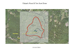
Oldpark for sale . 125 acres and approx £600,000 price tag. Link to sale details below. Local groups will consider possibilities this introduces including any ways to secure use for community.
Sale detail here
Location:

-------------------------------- 2012. The last episode
Thanks to all who responded to Tandridge by the 30th MARCH. The proposal for woodland operations was turned down by Tandridge DC on impact to local amenity.
ALERT. ALERT. ALERT. DEADLINE EXTENDED TO 30th MARCH
Latest news: Friday 30th March 2012

 Following the group photos on Monday , discussions and the blog entry earlier this week, new information came from people who had lived in the area from as far back as 1930.
Many local people are concerned at a new planning application for an access track and Forestry usage - right where a Mansion application was refused at appeal - Please respond if you are able to via Tandridge's Planning site . We understand it may be open until March 30th for on-line comments and emails. These additional comments our last chance!!!!!
ACTION: Please read this background and send an email quoting the ref no below, or fill out an on-line objection on Tandridge's web site. You may also use this site to inform others locally of what you think and we will make that content available to Tandridge too, although it is not the official route. Tom Bennington has also created a local facebook page for members of the War Coppice Village Residents group.
eMail Tandridge: comaps@tandridge.gov.uk or Sue Field
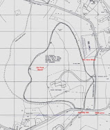
BackgroundThe owner's of the land behind Gravelly Hill have applied to begin Forestry operations and create an access into the land, where none exists today. Planning consent for forestry work will be allowed within the existing planning category for the site. The issue for the local community is that an access way proposed is on a totally unsuitable local road. The overal proposal is quite out of scale and out of character with the current use and will damage the area irreparably. Unfortunately given the nature of the application, normal objection grounds do not apply and there is limited time to reply.
Please consider in your responses the impact on:
LATEST INPUTS
- There is no trace any vehicle or machinery access has ever existed at this point on Gravelly Hill, despite an extensive search of maps and Ariel pictures going back to 1929. It would not have been a sensible location to enter and exit the land, as level and safe access was possible via the original house and related landholdings between the Ariels, Water Tower, Gravelly Place and Three Chimneys, along the ridge line of the North Downs, all of which formed part of the same estate. The current track appears only to have been formed by animals and those walkers who continue to access the woods, as has occured throughout the communities memory to date.
- The land itself is a mixture of overgrown scrubland, considered unsuitable for any form of sustainable forestry and some areas of semi- ancient woodland ( Existed prior to 1600), which either contain landmark trees, to which TPO's should apply, or have been clear felled in the past. However the existance of bluebells and wood anenomies demonstates those areas that have semi ancient woodland characteristics and which are a valuable habitat. These arguements were sustained in the Golf Course planning appeal in 1989 and are still relevant. We note that Caterham & Warlingham council issued TPO No 1 for the area after concerns that the owners of the land were intent on some form of development. Despite the TPO and the formation of the Green Belt, a significant number of mature trees were felled in semi ancient woodland areas. The landholding is understood to remain linked to the same ownership.
- The proposed area for forestry operations contains no timber that would justify an access road on the scale proposed. Clearance of scrub land has been performed nearby at Fosterdown Wood along the North Downs Way, using Landrovers, chippers and relatively light vehicles, by the Downland Project.( http://www.surreycc.gov.uk/environment-housing-and-planning/countryside/managing-the-countryside/countryside-management-projects/downlands-project)
- The actual access proposed is part way down a steep hill, just below the brow, after a blind bend. While forestry operations may not occur during the depths of winter when that hill is particularly badly affected by ice, it will still be a dangerous access through poor visibility, sight lines and so on, whether in sunshine, rain or the mists that are also a feature of the top of the North Downs.
- If large vehicles are intended to be taken into the area, the only apparant access need would be if more extensive clearance is proposed. We note that more dense (and historic) woodland is also a part of the original Oldpark landholding but the land contours are such that this access would not serve these. We can only speculate on its true purpose.
- Any additional and slow moving traffic would be an obstacle and hazard on this part of Gravelly Hill, so whether a large vehicle ( purpose unknown) or a lighter vehicle it would be slow moving and a hazard. The local road network is already busy with school and other traffic and sustainability is questionable.
Please note following this post two people with personal local connections have come forward to confirm that there has never been any access from Gravelley Hill and their comments communicated to Tandridge.
___________________________________________________________- Local roads and safety for all users. Access will be on a steep hill, which is often very icy in winter, just below the brow of the hill and a bend restricting visibility on a derestricted road.
- Local amenity at Viewpoint
- Visibility from miles around due to the elevation and skyline location
- Impact on an ANOB at Viewpoint
- Traffic including heavy plant on all the access roads
- Impact on leisure users locally including walkers, cyclists and horse riders
- The fact that the application failed to mention there was a metalled surface within 25 metres of the proposed works (Gravelly Hill)
- That notice was inadequate for an environmental impact of this scale, to all the users of Viewpoint and who live nearby
- Local wildlife that will be adversely affected by a 200 metre by 8 metres by 0.4Metre deep access construction and permament track into currently abandoned scrub and semi ancient woodland.
- A previous wildlife survey for the Mansion applications, indicated measures would be needed for protection of species including, bats, doormice ( Preservation of continuous Tree canopy), badgers, and other flora and fauna.
- A previous application considered that any access tracks would need to be constructed in such a way as to preserve nearby trees and their root systems.
- Some of the land contains semi ancient woodland
- It was considered important archeological remains existed crossing the site, where a previous park pale had existed for the Royal Hunting Lodge located at Place Farm, Beltchingley, to retain stock within a hunting wood.
- The strange co-incidence that the track passes the site of a mansion in 40 acrees, turned down at a planning appeal 12 months ago, as an exception to the green belt.
- A part of the proposed site was once natural dowland, it was not forestry. The area proposed also includes semi ancient woodland. The impact on the landscape will be long lasting and we question the real sustainability of a forestry proposal.
Summary
The proposal is for forestry use and a new trackway/access at Gravelly Hill. It is along a route proposed for temporary construction use as part of the "Mansion" proposal by the Harris Brothers, turned down at a planning appeal last year.
The land the proposed 'trackway' would open up runs directly to the location of the house refused at appeal. There is currently no track, or any evidence known if one ever existed. All that is currently there is a small animal/track or single width footpath that leads past a huge and old beech tree, which has sadly been a lightning strike casualty.
So far as we know there has not been an active forestry use, or in fact any use along this trail since before 1955, around the time the Harris family sold Hill House, which later became Gravelly Place.
It is a proposal to commence forestry use of the mapped area. We could anticipate that everything except the mature trees, could be harvested and of course, whatever is replanted, plus any ancillary buildings would improve the potential conversion possibility to residential later. Any trees replanted would hardly regenerate to anything like the current scale, and for many years. While clearing of old downland areas that have become scrubland is to be supported in some contexts, this proposal is dubious. The disturbance from tree felling, chipping or planking, or transport offsite on large vehicles, would have a significant local impact on narrow & rural lanes through the area. The full details are listed here: ( use the reference TA/2011/1558)
http://planning.tandridge.gov.uk/eaccess/AppNumberSearchResults.asp
(This link may take you straight to an online form to complete for your comments.....use
Some comments submitted around 5PM on Friday 30th March via eMail.
Dear Sirs
You probably have most of this, however I am sending those recent items from various people, following the Oldpark Blog's publication of Monday's group picture, and the confirming information which resulted from that.
1. The Oldpark Blog was updated with recent news
2. The info from Australia - A resident going back to the 1930's confirming no vehicle access ever existed.
3. A similar confirmation from the current owner of another nearby property.
4. We have English Heritage Ariel pictures of the area from 1929, 1949 and 1965. There are no indications of any access. Some felled areas are visible despite TPO no 1 from C&W UDC days. Old downland areas are also visible.
5. We believe Ordnance Survey 1st edition and later will confirm the ariel pictures and living residents statements going back over many years.
This is in addition to the material already submitted on-line.
We believe this fundamentally alters the submission. This is not for reinstatement of access. It is completely new and in an unsuitable location.
Surrey Highways need to consider on this basis.
We believe the forestry proposed is likely to be unsustainable and that the application is for a quite different purpose.
Regards
A local resident
This Blog was originally created to fight the mansion proposal last year, which has other background. Do look at the earlier editions. Both War Coppice Village Residents Association and the new Area 148 (Viewpoint) Neighbourhood Watch area and their members are welcome to contribute and post materials here or link to the site. Other groups have also linked up locally demostrating this is not simply a very localised issue but one affecting a wide area and many who value Caterham's green spaces.
http://oldparkwood.blogspot.com/
The 2010/2011 planning application for an "Exception" to the Green Belt failed on a number of grounds. It would have crossed an ancient earthworks, which is still visible and formed an original 'Park Pale', a means to keep game within an enclosure. At an appeal a temporary access was proposed on exactly the line of this proposed trackway, to allow for construction traffic and was then to be reinstated. A trackway, especially one where scrub was cleared on each side, would also have provided any house located near the old beech with a line of sight south over View Point.
The battle has restarted and with the Government changing planning rules, with its 'Presumption in favour of development', this is simply the start of a new fight. Although Green Belt is supposed to be protected as before, all sorts of powerful land owners and developers are queuing up to look for loopholes, while CPRE, The National Trust and newspapers such as The Times and The Telegraph have run campaigns against. The Government's proposals have the jargon NPFF - New Planning Policy Framework and were in fact released today - 27th March 2012.
http://www.communities.gov.uk/publications/planningandbuilding/draftframework
 ("Oldpark" The majestic old beech tree at the site of the proposed house. Photo taken on the site inspection during the planning appeal. CMW)
A photo albulm containing the "Oldpark" picture and other images is here:
Tom Bennington, the new chair of the War Coppice Garden Village Resident's Association, is a a key local contact.As some of you will know a new Neighbourhood Watch (148) has recently been started from View Point, back to Tupwood Lane and the Green Belt parts of Harestone Valley, Hill and Upper Harestone. Wendy Russell is coordinating that group and will hopefully be able to keep them aware of developments.
Other groups have also linked up to object to these proposals from Dome Hill and Harestone Valley.
"Oldpark"
Here is a Google Map link from View Point. The site is to the right hand side of Gravelly Hill, just beyond the 'SLOW' sign where the hill joins View Point.Tip Rotate the circle by clicking on the "n" and drag it round to about 3 o'clock to see Gravelly Hill and where the forrestry work is proposed. You can move up the hill by clicking the arrows and lines on the road.
View Larger Map