

ALERT. ALERT. ALERT
Latest threat: Weds 7th March 2012
 New Planning application for access track and Forestry usage - right where Mansion application refused at appeal -Please respond via Tandridge's Planning site or by letter by March 24th or it will be too late!
ACTION: Please read this background and either write a letter to Piers Mason at Tandridge Planning, quoting the ref no below, or fill out an on-line objection on Tandridge's web site. You may also use this site to inform others locally of what you think and we will make that content available to Tandridge too, although it is not the official route. Tom Bennington has also created a local facebook page for members of the War Coppice Village Residents group.
Background
The owner's of the land behind Gravelly Hill have applied to begin Forestry operations and create an access into the land, where none exists today. Planning consent for forestry work will be allowed within the existing planning category for the site. The issue for the local community is that an access way proposed is on a totally unsuitable local road. The overal proposal is quite out of scale and out of character with the current use and will damage the area irreparably. Unfortunately given the nature of the application, normal objection grounds do not apply and there is limited time to reply.
Please consider in your responses the impact on:
- Local roads and safety for all users. Access will be on a steep hill, which is often very icy in winter, just below the brow of the hill and a bend restricting visibility on a derestricted road.
- Local amenity at Viewpoint
- Visibility from miles around due to the elevation and skyline location
- Impact on an ANOB at Viewpoint
- Traffic including heavy plant on all the access roads
- Impact on leisure users locally including walkers, cyclists and horse riders
- The fact that the application failed to mention there was a metalled surface within 25 metres of the proposed works (Gravelly Hill)
- That notice was inadequate for an environmental impact of this scale, to all the users of Viewpoint and who live nearby
- Local wildlife that will be adversely affected by a 200 metre by 8 metres by 0.4Metre deep access construction and permament track into currently abandoned scrub and semi ancient woodland.
- A previous wildlife survey for the Mansion applications, indicated measures would be needed for protection of species including, bats, doormice ( Preservation of continuous Tree canopy), badgers, and other flora and fauna.
- A previous application considered that any access tracks would need to be constructed in such a way as to preserve nearby trees and their root systems.
- Some of the land contains semi ancient woodland
- It was considered important archeological remains existed crossing the site, where a previous park pale had existed for the Royal Hunting Lodge located at Place Farm, Beltchingley, to retain stock within a hunting wood.
- The strange co-incidence that the track passes the site of a mansion in 40 acrees, turned down at a planning appeal 12 months ago, as an exception to the green belt.
- A part of the proposed site was once natural dowland, it was not forestry. The area proposed also includes semi ancient woodland. The impact on the landscape will be long lasting and we question the real sustainability of a forestry proposal.
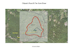
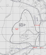
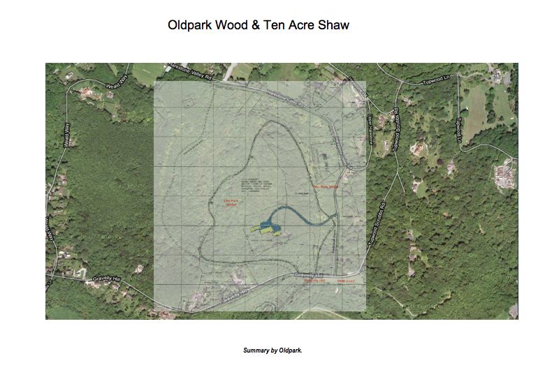
The proposal is for forestry use and a new trackway/access at Gravelly Hill. It is along a route proposed for temporary construction use as part of the "Mansion" proposal by the Harris Brothers, turned down at a planning appeal last year.
The land the proposed 'trackway' would open up runs directly to the location of the house refused at appeal. There is currently no track, or any evidence known if one ever existed. All that is currently there is a small animal/track or single width footpath that leads past a huge and old beech tree, which has sadly been a lightning strike casualty.
So far as we know there has not been an active forestry use, or in fact any use along this trail since before 1955, around the time the Harris family sold Hill House, which later became Gravelly Place.
It is a proposal to commence forestry use of the mapped area. We could anticipate that everything except the mature trees, could be harvested and of course, whatever is replanted, plus any ancillary buildings would improve the potential conversion possibility to residential later. Any trees replanted would hardly regenerate to anything like the current scale, and for many years. While clearing of old downland areas that have become scrubland is to be supported in some contexts, this proposal is dubious. The disturbance from tree felling, chipping or planking, or transport offsite on large vehicles, would have a significant local impact on narrow & rural lanes through the area. The full details are listed here: ( use the reference 2011/1558)
http://planning.tandridge.gov.uk/eaccess/AppNumberSearchResults.asp
This Blog was originally created to fight the mansion proposal last year, which has other background. Do look at the earlier editions. Both War Coppice Village Residents Association and the new Area 148 (Viewpoint) Neighbourhood Watch area and their members are welcome to contribute and post materials here or link to the site.
http://oldparkwood.blogspot.com/
The 2010/2011 planning application for an "Exception" to the Green Belt failed on a number of grounds. It would have crossed an ancient earthworks, which is still visible and formed an original 'Park Pale', a means to keep game within an enclosure. At an appeal a temporary access was proposed on exactly the line of this proposed trackway, to allow for construction traffic and was then to be reinstated. A trackway, especially one where scrub was cleared on each side, would also have provided any house located near the old beech with a line of sight south over View Point.
The battle has restarted and with the Government changing planning rules, with its 'Presumption in favour of development', this is simply the start of a new fight. Although Green Belt is supposed to be protected as before, all sorts of powerful land owners and developers are queuing up to look for loopholes, while CPRE, The National Trust and newspapers such as The Times and The Telegraph have run campaigns against. The Government's proposals have the jargon NPPF - New Planning Policy Framework.
http://www.communities.gov.uk/publications/planningandbuilding/draftframework
 ("Oldpark". The majestic old beech tree at the site of the proposed house. Photo taken on the site inspection during the planning appeal. CMW)
Tom Bennington, the new chair of the War Coppice Garden Village Resident's Association, is a a key local contact.
As some of you will know a new Neighbourhood Watch (148) has recently been started from View Point, back to Tupwood Lane and the Green Belt parts of Harestone Valley, Hill and Upper Harestone. Wendy Russell is coordinating that group and will hopefully be able to keep them aware of developments.
"Oldpark"
Here is a Google Map link from View Point. The site is to the right hand side of Gravelly Hill, just beyond the 'SLOW' sign where the hill joins View Point.
Tip Rotate the circle by clicking on the "n" and drag it round to about 3 o'clock to see Gravelly Hill and where the forrestry work is proposed. You can move up the hill by clicking the arrows and lines on the road.
View Larger Map