LATEST: Tuesday 6th July
APPEAL REFUSED!!!!!
Accordingly, I find that the proposed development is unacceptable and that the appeal should not succeed.
John Head
INSPECTOR
Appeal closed June 8th. Result awaited after 5-7 weeks, from mid July.
There was no conclusion reached. The inspector visited a number of places on June 9th to assess the local impact. This included Gravelly Hill, a field to the south of the M25/A25 looking back towards View point, Tilburstow Hill, Top of Harestone Hill and a few others.
We note a similar application by footballer Gary Neville, has just been turned down by local planners in Bolton. The key factor was local opposition, with over 100 objections.
Will publish any follow up on the blog and have created an on-line library that anyone can view. If you have additional images they can be added.
Many thanks for your all your comments and interest. Please pass on to any that need info.
Here are some of the images used at the appeal on June 8th and taken during the site visit which followed.
June 4th
New information released. Downloads here, otherwise little opportunity for public scrutiny or comment. Do use the blog to share comments with others.
To comment on the latest material please do two things:
1. Send an eMail with comments to the inspector's team, to be there by Monday 7th June afternoon, with your name & address. Copies as below.
2. Copy your comments for others to see on the Blog, with or without name & address.
We will copy any comments on the Blog to the Inspector too on Monday and deliver to the appeal on Tuesday 8th.
Email to: TeamP13@pins.gsi.gov.uk
cc oldparkwood@me.com
cc PlanningAppealsLegal@tandridge.gov.uk
Subject: Ref. APP/M3645/A/09/2112984/NWF & the Council ref. TA/2009/132
Click in download panel to left to get latest documents.
British Horse Society and Surrey Hills AONB Exec Summary added June 4th.
Do view and add comments at bottom of page for others to see!
 APPEAL : 8th June at 10.00 am, Council offices Tandridge District Council, Oxted.
Adjourned hearing to continue
Click letter image to download copy notice of meeting on 8th June. It advises some revised information is available at Oxted and other information to be provided at the hearing. Time is very short to make comments to the inspector at his Bristol address. We will provide any further detail we can, as available.Over 20 years ago, a golf course was rejected in the same location, by the same owners. The inspector's report refusing permission is provided here and via the left panel. Many of the same issues still apply and have been underlined in this copy of the report by a well know local historian and naturalist.
Ref TA/2009/132
http://planning.tandridge.gov.uk/eaccess/Applicationsearch.asp
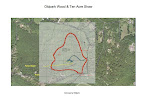
A planning application has been received by Tandridge District Council, for a very large scale house and associated staff acomodation in land known as Ten Acre Shaw, which is part of Old Park Wood. It is in its own site of just over 35 acres ( 13.8 Hectares) of mixed woodland and old downland near View Point and is currently part of the attractive landscape enjoyed by many Caterham residents.
Content provided by the War Coppice Village Residents Association and others living nearby.
A summary of the points raised at the appeal hearing & contributed comments.
The key points were that the various maps showing ownership and particularly the proposed access routes and directions, were not accurate, needed further information as a result and would trigger the need for further public consultation
Details:
1. It was adjourned until June 8th, Several serious issues were raised, over inaccurate statements and information. There will be another opportunity to comment now based on revised info.
2. Kendrick represented the Harris brothers. Jack and Peter Harris were there and from time to time it got quite lively.
3. There are 7 basic areas the inspector proposes to review and almost all ended up needing further input, clarification or expert views.
2. Kendrick represented the Harris brothers. Jack and Peter Harris were there and from time to time it got quite lively.
3. There are 7 basic areas the inspector proposes to review and almost all ended up needing further input, clarification or expert views.
- Whether the development is "Inappropriate" within the various policies that apply, given the policies documented in Tandridge's case, or affecting development here. These include: design, biodiversity, impact on AONB areas, travel, support within the local plan (LDF) and some others.
- The impact on the area.
- Impact on tree cover, woodland and any protected species.
- Archeological impact
- Roads, Access and Safety
- Sustainability aspects
- Overall PPS7 case for an exemption to Green Belt policy
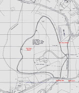
4. Access to the site is proposed from View Point, down the unused trackway, that is now a Bridleway (184). This may have no legal right of vehicle access. The Harrises claim they have a right of way onto it, based on the deeds to the land. A key document in the submission showed access would be via the North, down the trackway and then out past Caterham School. This passes over bridleways 184 and 183 but these have no vehicle rights of way, except for owners of existing properties served by it. The law changed recently and public rights were terminated, unless rights of way were registered, whether for footpath, or bridleway or vehicles. Apart from that, the cost of making the track passable, environmental impact, cost and subsequent maintenance costs are all major issues. As the submission in one place stated the access route would be from the North and elsewhere was unclear, such objections as there were, had been based on interpretations not facts. Surrey CC correctly concluded that access had to be from the South but many others did not. ( See comments by both Avril Sleeman and Jackie Servant below)
5. It appears that Mr Charles Daniels owns the land over which the bridleway passes and strips either side. Info obtained from the Land Registry - Avril Sleeman. This confirms statements made by David Barber, that Charles Daniels is the owner, was not approached and not in favour. Several of us wrote accordingly back in August. There is an action to contact Mr Daniels to request he provides his address, so he can be contacted to state his position himself.
5. It appears that Mr Charles Daniels owns the land over which the bridleway passes and strips either side. Info obtained from the Land Registry - Avril Sleeman. This confirms statements made by David Barber, that Charles Daniels is the owner, was not approached and not in favour. Several of us wrote accordingly back in August. There is an action to contact Mr Daniels to request he provides his address, so he can be contacted to state his position himself.
6. The original submission and later maps submitted all contain errors claiming that land up to the bridleway was owned by the Harrises. This appeared to tip the scales in favour of a deferral while correct information was verified and submitted.
7. Access from View Point, brings highways concerns about safety and visibility. A traffic speed survey is proposed plus potential tree loss for sight lines. Ecological impacts to be reviewed in the vicinity and surveys of Bats, Badgers, Door mice and possibly adders to be carried out. A second temporary access likely from the footpath issuing near top of Gravelly Hill. The site of the large fallen Beech Tree this path leads to, is more or less the site of the house and a temporary access along here is the probable plan. Given the need to bring in large pre-constructed panels and steel beams, one can only imaging the chaos, damage and ecological impact of a second access for construction at this point.
8. The actual landscape designation is Green Belt and AGLV ( Area Great Landscape Value). It adjoins View Point which is part of AONB - a higher designation and the access clarification will be referred to English Nature, CPRE etc. The statements that the site was not overlooked were jumped on by several of us. I pointed out that the Tupwood Lane, Tupwood Scrubs and Harestone Hill skyline was at same height and overlooked the proposed site. Mottrams is also likely to be in direct view from up the "Valley" towards View point and Gravelly Hill skyline. Others pointed out that the skyline was visible to many from the south of View Point and it was a potentially dominant site, through siting and potential mass. ( Contact with CPRE now initiated, plus Surrey team responsible for AONB's)
9. Various negative comments about the buildings proposed by all the objectors. Viz, Concrete, steel & glass, with large white rendered blocks in the middle of a dominant and wooded landscape. Refuted by Kendrick with arguments that did not carry weight with most but inspector the key. A negative architectural assessment from a firm advising Tandridge met with nods from the audience. Nobody supported the notion this was a building of exceptional merit, only that it would be a blot on the landscape.
10. Mention made of public access on foot to the woodland via a Section 106 agreement. This is mostly about the carrot dangled of allowing some access to the rest of the site but this provoked strong comments all round. Get off our land vs Don't ruin our amenity. Other discussions over sustainability, car parking spaces, distance to physically walk over suitable paths or roads into Caterham for shops, rail etc, or to any school except Caterham School.
11. Good attendance and points made by Messrs Cooper, Connolley and Servant and Tandridge clearly in opposition to the proposals and the various objections were well summarised. About a half dozen interested residents and a bigger showing would be an advantage for June. Gwyneth Fookes present and provided helpful expert comments, especially over designation of 10 Acre Shaw which is classified as Ancient Woodland ( Existed in 1600). Some earth bunds are visible in the area and it has been suggested they may be park pales - a boundary to keep deer enclosed in hunting areas. I commented of the existence of a Royal hunting lodge in Bletchingly - Place Farm (Palace) etc and the trackway leading towards it from Gravelly Hill. Bourne Soc records may reveal more. This was associated with preserving any archeological features that could be harmed by development....it appeared there will be a call for a "Desk" check of possible information. ( See note from Gwyneth Fookes below)
12. Tandridge will be instructed by the inspector to re-advertise the present situation and call for further comment. Some press were there and anticipate a story in Caterham Mirror by David Farbrother who attended towards the end. We will also pass these details to other local media.
Avril Sleeman BHS CABO Surrey
A minor correction to point 4.The important fact about the NERC Act 2006 is that , except in a minute number of cases, BOATS can no longer be created by way of usage in the past (S 66 and 67) nor any current BW or FP be upgraded to a BOAT. (You can still claim for FPs or BWs or even Restricted Byways on the basis of use but nothing carrying vehicles) Consequently any claim that BW 184 was wrongly designated is irrelevant even if that were the case at the time; only two out of 20 applicants at the time mentioned vehicular traffic use so Surrey never considered a BOAT to be appropriate. I have re read the Officers report from 7th February 2001 and she states that ALL adjacent landowners were informed of the claims for 182,183 and 184contrary to what the Harrises admitted yesterday. I have asked her to check SCC’s files to ensure that the Harrises or their representative were informed and she will supply me with correspondence, if available, for my representative at the next Hearing.
The issue of the BOAT never came up in their original Appeal letter and I have a feeling that if they have private rights to drive on the BW 184 they would have produced evidence of this rather than questioning the public status of the way. I have also contacted the SCC AONB Officer to advise her of the change of exit at View Point and the implications of opening up a “temporary” access for construction traffic. Again I never saw any reference to this in the documents I accessed on line. We need to take care that this “temporary” entrance does not become a permanent one when they realise they cannot drive down 184 so Tandridge Planning must ask that should the Appeal be successful, there are strict conditions for its closure be adhered to; we do not want a repetition of the North Park Farm Sandworks situation where every contravention of Planning permission has been met with a retrospective permission from SCC.
I will also take some photos north from Rabies Heath Road and the BWs near the Orpheus Centre where the skyline at View Point is very obvious. As I said yesterday I’m sure I read something on one of the local Plans about skylines being preserved so Chris Hall may care to look that up, since the level of tree destruction at View point to allow safe sight lines both at BW184 and the construction route will change the skyline for all time.
Jackie Servant.
Access (Ref 4): The original plans showed access from the North via Upper Harestone. Some bushes/small trees have been cut back recently near the junction. The applicants appear to have changed course during the hearing, now applying for access from the South (the View Point end of the track) as you say. Was there notification of this change beforehand ?
Gwyneth Fookes.
Ref 11. Sadly the archaeological features will not protect the site from the development, yet it will ensure some checks are made. And I do like the idea the SCC archaeologist presented that archaeological investigation must precede any development in previously pristine land. The banks on site ARE the park pale - mapped in the 18th century that I know of and documented back to the 14th. Mary Saaler is the local expert. It was in the estate of Place Farm, once occupied by Anne of Cleves, who enjoyed hunting and I like to think she may have hunted in Old Park - that is not evidence of course!
The ancient woodland designation is a powerful protection and their argument that the trees were felled in 1949 (when the Harrises wanted to build all over the site then!) carries no weight at all. The woods are still ancient woodland.
Background
The original date for submitting an objection closed on Monday 3rd August. Many individual letters were received by Tandridge and you can see them on their web site listed at the top of the page.
These letters make interesting reading and are well sumarised by Tandridge in the officers report.
A Petition was submitted with over 150 names and many individual letters. Thank you everyone.
This is roughly to west of bridleway from View Point to Upper Harestone. The application TA/2009/132 can be seen at www.tandridge.gov.uk. This is for a very large house, stores, garages and staff accommodation.

The destruction to trees and disruption would be immense. The area would also appear to be fenced off so both public and wildlife will not be able to move freely as they do now.
We are anxious no precedent is established in this vulnerable area and this plot and Old Park Wood do not come under pressure and perhaps be lost. It is within an area of high landscape value, part of the Green Belt and contributes greatly to the character of the area.
We provided this guidance previously based on a review of different peoples input. It is not exhaustive but should provide a helpful summary.
Ref: TA/2009/132
Planning Dept
Tandridge District Council
Station Road East
Oxted
Surrey
RH8 0BT
Dear Sirs
1. As residents we enjoy the amenity of Old Park Wood and Ten Acre Shaw which are currently quite unspoilt parts of the local landscape.
2. The application suggests there has been consultation with local residents and groups. We have been unable to discover anybody who supports this assertion and the overall feedback is to oppose the application. The application also fails to disclose the Golf Course Application that was refused circa 1989.
3. A landowner over whose land access is required has stated he was unaware of the application, and objects.
4. This unusual planning application has been made in the Green Belt locally for a house which is quite out of scale with anything nearby.
5. It is in Green Belt and various other designations apply. We note that the application is for a major private residence, for the benefit of a very small number of potential residents. By allowing this, it would destroy an unspoilt part of the area and risk further incursions later if access and precedent is achieved. Some might see this as the first step in a coordinated plan to erode this parcel of Green Belt.
6. There are existing but unregistered footpaths used by the public that cross the site.
7. The house will be sited to benefit from views high up on the North Downs. It will therefore be visible from many places and despite the statements made in the planning application; it is of a size, scale and construction that will irreparably alter the landscape.
8. Access routes to the site will rely on a trackway, which is not currently used by vehicles. For construction and later access by residents, we are very concerned at what is proposed by way of upgrades to that under S106 or other provision and any change to potential traffic flow in a "no traffic" zone today.
9. Only 4 households have been notified of this. Planning notices went up on 9/7/09 so far as we are aware. On the other hand the proposal will affect the amenity of many.
10. The suggestion that consultation has occurred locally clearly has not been widespread; in fact nobody contacted who lives near the site is aware of any at all.
11. Accordingly we are alarmed at the extent of the impact of this development and although statutory requirements have been complied with, have taken the initiative to make information available as widely as possible. We contend that the building of such a house in green belt requires community wide debate. If PPS7 is to be the justification, we see no merit in either the house, its impact on the landscape, or the creation of access to fragile woodland.
12. We would contend that where green belt rules are to be changed or broken there should be a benefit to the community, but in this case the local amenity will be considerably damaged. The peace of The Viewpoint will be affected, traffic will emerge there in what is currently a wonderful focal point for walkers, and the habitat of the local deer, foxes, badgers and rabbits will be impacted.
* The North Downs Way will be compromised.
* A very pleasant bridal path will become a road and a traffic rat run may develop.
* Even if planning permission were to be granted there is an argument for making the access to the site come from the North West and leaving the current bridleway unaffected.
13. There is a considerable disbenefit to the community but on the other hand the applicant will gain considerable wealth by the awarding of planning permission and the conversion of presently low value land into an extremely high value building plot.
14. The impact is also extremely large for the sake of a single one family dwelling house, although the drawing would indicate that this could easily be converted to a hotel or clubhouse, in the future.
15. The point here is that if there is huge wealth to be created by the granting of planning permission process, then that wealth should go to the community, and so the applicant should be required to pay in some way the difference in value of the plot as it stands and the value when planning permission is granted. Not to consider this route is like handing the applicant a blank cheque.
16. CO2 consideration. To significantly impact 35 acres of prime woodland in what must be the lungs of London for the sake of building one dwelling for one family is just not consistent with responsible climate philosophy.
Despite statements that the house is ecologically advanced, it is clear large tracts of the site would be cleared, otherwise there would be little interest to buy a house in a densely wooded part of the Surrey Hills, without a significant open space and clearings to provide views of the vista from the site's elevated position.
Other points made in letters to Tandridge:
Any removal of trees in the designated site may have an adverse impact on motorway noise that is transmitted to those in Harestone Valley area.
Any change to the surface of the trackway and local run off from the site may channel additional "Storm" water into Harestone Valley, via the old trackway running towards Caterham School with an adverse effect.
http://oldparkwood.blogspot.com/